
POMAR NAME AND COAT OF ARMS
OTHER INFORMATION


POMAR
A toponymic (relating to place names) surname, and therefore of many places of origin. In Cantabria, it is said that one had a plot of land in the Castaneda Valley, Pomaluengo (?) and from there passed through Alfoz de Lloredo and the Sietevillas de Trasmiera, where he had his noble house in the place of Ajo. His arms are: a shield in a field of gold and in it five red apples in sotuer or formed like a slanted cross. Others placed on a field of red, an apple tree with golden fruits, having a bear standing on its hind legs and touching the trunk with forepaws. From the noble house in Ajo, descended the Rev. Father Pomar, a resident Jesuit and native of Chile, who did a family study and brought as coat of arms a band with one star in each canton (upper dexter or right corner), possibly due to linkages with the lineage of Barrio Ajo, which ended up with the Pomars! Those of this surname in Ruiloba, had a branch that passed through Jerez de la Frontera and another two to Peru, with notable descendants.
MC GONZALEZ ECHEGARAY,
Escudos de Cantabria, Pl pag 159
Translated to English by
Edwin D. Bael

So, what we use - an elaborate crest emblazoning a coat of arms that can
be described as "escudo de oro con cinco manzanas de gules en sotuer,
bordura de gules cargada de ocho aspas de oro" or "shield of gold with five
red apples positioned like a diagonal cross, bordered in red, with eight
diagonal crosspieces in gold" - approximates the arms of the noble one from
Ajo place which was a "shield in a field of gold and in it five red apples in sotuer",
albeit a bit more with the border and the crest...
Pomar Coat of Arms / Pomar Family Crest
(German-Polish Heritage)

This surname of POMAR is
of two-fold origin. It was a German occupational name for an importer or seller
of bitter oranges or a locational name meaning 'one who came from Pomerania', a
province of Poland with sea-coast, on the Baltic, which was formerly part of
Prussia. The name was derived from the German POMERANZE, and rendered in
ancient documents in the Latin form POMARANCIA. Other spellings of the name
include POMERANZ, POMERANTS, POMERANCE, POMRINCE, POMRINSE, MARANC, MARANS,
POMARANSKI and MARANTENBOIM, to name but a few. Habitation names were
originally acquired by the original bearer of the name, who, having lived by,
at or near a place, would then take that name as a form of identification for
himself and his family. When people lived close to the soil as they did in the
Middle Ages, they were acutely conscious of every local variation in landscape
and countryside. Every field or plot of land was identified in normal
conversation by a descriptive term. If a man lived on or near a hill or
mountain, or by a river or stream, forests and trees, he might receive the word
as a family name. Almost every town, city or village in early times, has served
to name many families.
Wikipedia
E-MAIL DISCUSSION ON NAME, SHIELD, HERITAGE
Segun el Libro: Nobiliario de los Reinos
y Señoríos de España
Por D. Francisco Piferrer
Tomo II, página 237, Num. 1031
Madrid, 1857.
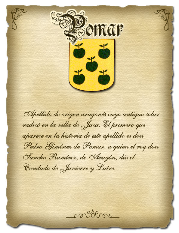
El rey Don Sancho Ramirez de Aragon, que floreció en la segunda mitad del siglo XI, dió por los años de 1081 el condado de Javiere y Latre á un deudo suyo, llamado Pedro Gimenez de Pomar, el primero que aparece en la historia con este apellido; por lo cual debe conciderarase como tronco y principal ascendiente de este ilustre linage de Pomar, cuyo antiguo solar infanzonado radicó en las montañas de Jaca, en el reino de Aragon, y cuyos esclarecidos descendientes fueron ricos-hombres de pendon y caldera, y calidad que se consideraba en aquellos tiempos aproximadamente como en los nuestros la de grande de España. Esparcidos los hijos de dicho solar en varias provincias, han manifestado en todas partes con preclaros hechos y nobles hazañas de hidalguía de su generosa y regia estirpe, siendo muchos los que a semejanza del animoso y prudente Ulises, y segun la feliz espresion de arzobispo de Cambray, se han distinguido no menos por su valor en los combates que por su prudencia en los consejos . Un hijo de Pedro Gimenez ganó a los moros el lugar de Sadillas; y en premio a su valor le dió el señorío de dicho lugar el referido rey Don Sancho Ramirez. En el siglo XIII florecieron algunos insignes hijos de la casa de Pomar, y prestaron señalados servicios á su deudo el rey Don Jaime de Aragon, ya en los bandos y disturbios que al principio de su reinado promovieron algunos ricos-hombres, ya mas adelante en sus guerras con los moros. En el año 1225, persiguiendo el espresado rey Don Jaime á Don Pedro de Ahones, que despues de faltarle al debido respeto y obediencia, se habia escapado para no dejarse reducir á prision; entre los pocos caballeros que acompañaban al rey, se hallaba Domingo Lopez de Pomar, caballero mesnadero de su real casa, le acompañó en su entrada en Huesca. Gil de Pomar le sirvió en las guerras contra los moros de Valencia, y pobló el lugar de Carpesa. Nos parecen edemás dignos de mencion Carlos de Pomar, que al frente de mucha caballería asistió a la jura del rey Don Miguel en las córtes de Zaragoza, y en la memorable de los Reyes-Duques: Don Martin Lopez de Pomar, rico-hombre, gobernador de la villa de Epila, uno de los caballeros de mas valor y mérito de su tiempo: Pedro Gimenez de Pomar, tan célebre en lo político como en lo militar, elegido por el rey Don Pedro IV de Aragon para proceder á castigar á los culpados de la union de Algecira, siendo despues capitan y defensor de las montañas de Jaca por la parte misma donde radicaba su casa solar infanzonada, mereciendo por sus altos hechos ser aclamado y apellidado padre de la patria: Gimen Perez de Pomar, que asistió al juramento de los archiduques en las córtes de Zaragoza. Son las armas de este esclarecido linage de Pomar, un escudo de oro, y en él cinco pomas ó manzanas puestas en sautor, de color sangre, con el pezon de sable. Conforme la legislacion Española los Municipios no pueden usar su Escudo sin autorización, sin embargo no prohibe en ninguna forma usar el escudo familar. de otro lado su existe autorización real para nuestro Escudo Familiar.
According to the Book: Nobility of the Kingdoms and Dominions of Spain
By D. Francisco Piferrer
Volume II, page 237, No. 1031
Madrid, 1857.
King Don Sancho Ramirez of Aragon, who flourished in the second half of the eleventh century, around the years of 1081, gave the County of Javiere y Latre to a relative of his, named Pedro Gimenez de Pomar, the first who appears in history with this surname; hence he must be considered trunk and main ancestor of this illustrious lineage of Pomar, whose ancient noble settlement was situated in the mountains of Jaca, in the kingdom of Aragon, and whose enlightened descendants were wealthy men, of banner and cauldron (denoting royal authority to lead and feed men), and whose quality was considered at that time to be approximately like those of ours of the great in Spain. The sons of this noble house, having spread in several provinces, have manifested everywhere with illustrious deeds and noble feats of chivalry from its generous and royal lineage, there being many who, in like manner as the brave and wise Ulysses, and according to the happy expression of the Archbishop of Cambray, have distinguished themselves not only for their valor in combat but also for their prudence in counsel. A son of Pedro Gimenez gained the locale of Sadillas from the Moors; and as a reward for his valor, the said King Don Sancho Ramirez gave him the lordship of the place. In the thirteenth century, some illustrious sons of the house of Pomar flourished and gave noteworthy services to their kinsman the King Don Jaime of Aragon, first against the riots and disturbances that some rich men instigated at the beginning of his reign, and later in his wars with the Moors. In the year 1225, as the said King Don Jaime pursued Don Pedro de Ahones, who had escaped to avoid being reduced to prison after failing to give due respect and obedience, among the few gentlemen who went together with the King, was Domingo Lopez de Pomar, knight of the armed retinue of his royal house, who accompanied him on his entry into Huesca. Gil de Pomar served him in the wars against the Moors of Valencia, and populated the place of Carpesa. We think also worthy of mention: Carlos de Pomar who, at the head of a huge cavalry, attended the swearing in of King Michael in the Courts of Zaragoza, and in the commemoration of the Kings-Dukes: Don Martin Lopez de Pomar, rich-man, governor of the town of Epila, one of the gentlemen of much value and worth in his time: Pedro Gimenez de Pomar, celebrated in both political and military affairs, chosen by King Don Pedro IV of Aragon to proceed and punish those guilty of the union rebellion of Algeciras, being thereafter, captain and defender of the mountains of Jaca, the same place where his noble home was located, meriting by his exalted deeds being acclaimed and named the father of the nation: Gimen Perez de Pomar, who attended the Oath Taking of the ArchDukes in the Courts of Zaragoza. The arms of this illustrious Pomar lineage are: a shield of gold, and on it five pomes or apples placed in sautor (like a slanted cross), having red color like blood, with black-tinctured point. Pursuant to Spanish law, municipalities cannot use coats of arms without authorization, but there is no prohibition in any way against using family shields, on the other side of the existing royal authority for our family crest.
· · · May 15 at 11:38 pm
[English Translation by Google automatic translator, refined by EDB]
Bertha, conozco los tomos de D. Francisco Piferrer y entre otros, la Enciclopedia Héraldica y Genealógica de los hermanos Garrafa, en la cual dice: "Es probable que los Pomar de la Montaña de Santander, fueran originarios, y tomasen su nombre por apellido, de la aldea llamada Pomar, que pertenece al partido judicial de Castro Urdiales, y no dedechamos la posibilidad de que fuera el apellido el que diera nombre a la aldea, aunque de ambas suposiciones parece mas acertada la primera. Estos Pomares residieron en diversos puntos de la provincia de Santander, y algunos de sus descendientes pasaron a Jerez de la Frontera, Chile y Perú. Tuvo casas en el lugar de Arnuero, del partido de Santoña; en el Ruiloba, del partido de San Vicente de la Barquera, y en el de Castañeda, del partido de Villacarriedo" Se desprende de estos datos que no tenemos la misma raiz que el linaje aragones y por tanto el escudo a pesar de ser del linaje Pomar no es el nuestro, desconozco si alguno de nuestros antepasado fue merecedor de escudo de armas, en tal caso, ése si sería nuestro escudo.
May 16 at 12:18am · ·  3
3
3
Bertha, I know the volume of D. Francisco Piferrer and among others, the Heraldic and Genealogical Encyclopedia of the Garrafa brothers, in which it says: "It is likely that the Pomar of the Mountain of Santander, had originated from, and had taken as their surname the name of, the village called Pomar, which pertains to the judicial administrative district of Castro Urdiales, and we do not totally discount the possibility that it was the surname that gave to the village its name, although of both of these suppositions the first seems to be more correct. These Pomars resided in various parts of the province of Santander, and some of their descendants moved to Jerez de la Frontera, Chile and Peru. They had houses in the place of Arnuero, part of Santoña; in Ruiloba, part of San Vicente de la Barquera, and in that of Castaneda, part of Villacarriedo”. It is clear from these data that we do not have the same root as the Aragon lineage and therefore the shield, despite being of Pomar lineage, is not ours; I do not know if any of our ancestors was deserving of a shield of arms; in that case, that would, yes, be our shield.
[English Translation by Google automatic translator, refined by EDB]
POMAR ARAGON HERITAGE
Pomar
El primero que aparece en la historia de este apellido, es don Pedro Giménez de Pomar a quien el rey don Sancho Ramírez, de Aragón, dió el Condado de Javierre y Latre. Por tanto, debe tomarse como tronco del linaje Pomar, cuyo antiguo solar radicó en la villa de Jaca, siendo por tanto aragonés. De siempre, los hijosdalgo de este linaje prestaron valiosos servicios a sus reyes, resaltando aquellos que lo hicieron bajo los estandartes del rey don Jaime I, de Aragón. Pedro Giménez de Pomar, fue elegido, por el rey don Pedro IV, de Aragón, para reducir a los rebeldes de “la Unión”, en Valencia, siendo después nombrado como capitán y defensor de las montañas de Jaca.
Armas: Un escudo de oro y en él cinco pomas o manzanas puestas en sotuer, de color de sangre, con el pezón de sable.
The first who appeared in history of this surname is Don Pedro Gimenez de Pomar to whom King Don Sancho Ramirez, of Aragon, gave the County of Javierre y Latre. Thus, he must be taken as the trunk of the Pomar lineage, whose ancestral home was established in the town of Jaca, being therefore Aragonese. For a long time, the noble sons of this lineage lent valued services to their kings, notable of whom were those who did so under the banners of the King Don Jaime I, of Aragon. Pedro Gimenez de Pomar, was chosen by King Don Pedro IV, of Aragon, to control the rebels of “the Union”, in Valencia, being thereafter named as captain and protector of the mountains of Jaca.
Arms: A shield of gold and in it five poms or apples placed like a slanted cross, of blood color, with black point.
English translation by Edwin Bael
POMAR ESCUDO AS USED IN ARGENTINA

Note the green leaves on the 5 apples and image of the sea at the bottom...
MAPS AND INFORMATION ON PLACES
PERTINENT TO POMAR
Regions of Spain

The Autonomous Region of Cantabria

Cantabria
From Wikipedia, the free encyclopedia
Cantabria
is a small autonomous community centered around the port of Santander on the
northern coast of Spain. It is bordered by Asturias to the west, the Basque
Country to the east and Castilla y León to the south.
Map of Cantabria

Geography of Cantabria
The
natural boundaries of Cantabria are the Bay of Biscay to the north and the
Cantabrian Mountains and the Picos de Europa to the south. The impressive
mountain range is broken by fast flowing rivers which carve out some
spectacular valleys and form bays and estuaries upon reaching the Bay of
Biscay. One river though, the Ebro – which some say gave its name to the
Iberian Peninsula - rises here and flows south-east to reach the Mediterranean
in its delta in southern Catalonia. The mountains form a natural division
between Green Spain of the north and the more traditional landscape and weather
of the remainder of the country.
History of Cantabria
The
famous cave paintings of Altamira show that there were people living here at
least 15,000 years ago and there is other evidence to support this. The
Cantabrians were known to have given fierce resistance to the Roman occupiers of
Hispania; the Romans never being able to do much more than rule the cities they
had captured. When, in 409, Roman influence subsided, Cantabria was able to
assert its independence until the Visigoths, in 574, under the leadership of
King Lievigild, created the Duchy of Cantabria and used it as a frontier zone
for their territory. As with the Roman occupation, though, many Cantabrians
fled outside the controlled areas to continue to live their independent lives.
However,
when a mixed Berber and Arab invasion force took over the Cantabrian capital
city of Amaya, many local inhabitants joined forces with the neighbouring
Kingdom of Asturias. One of the consequences of this became that, for many
years, Cantabria lost its own political identity – being swallowed up and
looked upon as just the coastal part of Castile. Although references to
Cantabria remained, it was not until 1727 that there was an unsuccessful
attempt to recreate the geographical unity of the region. What had become known
as ‘the nine valleys’ became constituted as the Province of Cantabria in 1778,
but there was still dispute about the official name as Santander, the capital,
was continuing to insist in 1821 that its name should be used for the whole area.
Just when it looked as if the old name of Cantabria was likely to be
re-introduced formally again, the Civil War began, and at its conclusion Franco
insisted that the area was to be known as the Province of Santander.
It was not until 1982 that the autonomous community of Cantabria became fully recognised as a region.
Language in Cantabria
The
only official language of the region is Castilian Spanish although there are a
few people in the areas of the Pas and Soba valleys who still speak a Mountain
Language known as Cantabrian although it has no official recognition at all.
Economy of Cantabria
Two
thirds of Cantabria’s working population is now employed in the service sector,
which underlines the changes in the region during the past half century.
Tourism has developed, along with the growing percentage of the population that
live in and around the urban centres. The traditional cattle rearing and diary
farming, whilst still important, cannot sustain the numbers of employees it
once did. The area also grows a considerable amount of potatoes, corn and other
vegetables and there is a thriving fishing industry. Cantabria is also a centre
for paper production, textiles and the chemical industry.
Flag of Cantabria

Climate of Cantabria
The
region’s temperature has often been described as a humid oceanic climate,
characterised by warm summers and mild winters. Some of the mountains in the
Picos de Europa, though, experience an alpine climate, having snow for the
major part of the year. The annual rainfall at the coast is around 1200mm, but,
again, this is higher in the mountain areas. One interesting weather feature,
especially in the autumn and winter months, is the microclimate caused on the
coast by the ábrego wind, which can raise the temperature so that you get very
pleasant warm and dry days throughout the year.
Comarcas of Cantabria
A comarca is roughly equivalent
to a US "county" or a UK "district"

Comarcas administrativas de Cantabria, España.
Costa Occidental
Besaya
Santander
Trasmiera
Costa Oriental
Liébana
Saja-Nansa
Pas-Miera
Asón-Agüera
Campoo-Los Valles
The Western Coast District of Cantabria
Comarca de Costa Occidental de Cantabria
Comarca de Costa Occidental de Cantabria
From Wikipedia, the free encyclopedia
Flag
Coat of arms
Country Spain
Autonomous community Cantabria
Province Cantabria
Capital San
Vicente de la Barquera
Municipalities 1 Val de
San Vicente, 2 San Vicente de la Barquera,
3 Valdáliga, 4 Comillas, 5 Udías, 6 Ruiloba,
7 Alfoz de Lloredo, 8 Santillana del Mar, 9 Suances
3 Valdáliga, 4 Comillas, 5 Udías, 6 Ruiloba,
7 Alfoz de Lloredo, 8 Santillana del Mar, 9 Suances
Area •
Total 317.84
km2 (122.72 sq mi)
Population
• Total 20,192
• Density 64/km2
(160/sq mi)
Demonym costeroocidental
Time zone CET
(UTC+1)
• Summer (DST) CEST (UTC+2)
The Western Coast of Cantabria is a “comarca”
of said Spanish autonomous community (regional government) which comprises the
municipalities of Val de San Vicente, San Vicente de la Barquera, Valdáliga,
Comillas, Udías, Ruiloba, Alfoz de Lloredo, Santillana del Mar and Suances.
As its own name indicates, this comarca
extends over the western coast of the autonomous community, from its border
with Asturias by the mouth of the Deva River, to the Saja-Besaya mouth in
Suances; although these limits may vary depending on the source, since this
comarca, as the rest of Cantabria's, is not regulated, there are common
characteristic elements in the municipalities that belong to it.
This zone has great tourism assets like
beaches, nature, gastronomy and culture. Santillana del Mar, Comillas, Suances
and San Vicente de la Barquera are the municipalities of greater renown, both
in the comarca and in Cantabria, so they are the main destinations for
tourists. Three of the longest rivers of
Cantabria flow into the Western coast: The Deva, the Nansa and the Saja-Besaya.
In addition to the numerous beaches, the Oyambre Natural Park and Mount Corona
stand out as natural attractions.
As has been mentioned, the culture of
the zone is quite remarkable, since in a few kilometers-radius many cultural
spots are concentrated: the Altamira Cave and Museum, the Zoologic and Botanic
Garden, the Collegiate Church in Santillana del Mar; and the Sobrellano Palace,
the Comillas Pontifical University and the Caprice of Gaudí in Comillas.
The Cantabrian West is a mainly
touristic comarca, that opposed to the East, had remained safe from massive housing developments because of the lateness of the construction of the
Cantabrian Motorway, completed in the early 2000s
The Town of Comillas,
Western Coast, Cantabria, Spain
Western Coast, Cantabria, Spain
From
Wikipedia, the free encyclopedia
Location
in Spain
Coordinates:
43°23′13″N
4°17′22″WCoordinates: 43°23′13″N 4°17′22″W
Country
Spain
Autonomous
community Cantabria
Province
Cantabria
Comarca
Western Coast of Cantabria
Judicial
district San Vicente
de la Barquera
Capital
Comillas
Government
• Alcaldesa María Teresa Noceda Llano
(2007) (PRC)
Area
• Total 18.61
km2 (7.19 sq mi)
Elevation
23 m (75 ft)
Highest
elevation 210 m (690 ft)
Lowest
elevation 0 m (0 ft)
Population
(2008)
• Total 2,483
• Density 130/km2
(350/sq mi)
Demonym
Comillano, na
Time
zone CET
(UTC+1)
• Summer (DST) CEST (UTC+2)
Comillas
is a small township and municipality in the northern reaches of Spain, in the
autonomous community of Cantabria. The Marquisate of Comillas, a fiefdom of
Spanish nobility, holds ceremonial office in the seat of power at a small
castle which overlooks the town. The first Marquis of Comillas was Antonio
López y López (died 1883). Founder and owner of the Compañía Transatlántica
Española, he was born in Comillas in 1817. Antonio López y López was given the
title in 1878. The second Marquis of Comillas was his son Claudio López Bru.
The current Marquis of Comillas is Don Alfonso Güell y Martos.
The Town of Ruiloba,
Western Coast, Cantabria, Spain
Western Coast, Cantabria, Spain
Ruiloba is a third-order administrative
division in the region of Cantabria, the country of Spain with an average
elevation of 161 feet above sea level. The area is not very densely populated
with 168 people per mile2 and a total population of around 760 people. The
nearest town larger than 50,000 inhabitants takes about 0:45 hour by local
transportation. Ruiloba can have low impact (v or less)
earthquakes (on average one every 50 years), with occurances at <5 Richter.
When an earthquake occurs, it may be felt indoors by many people, outdoors by a
few people during the day. At night, some people may be awakened. There is a
low occurence of periods with extreme drought. September
is on average the month with most sunshine. Rainfall and other precipitation
has no distinct peak month. Ruiloba
has a humid (> 0.65 p/pet) climate. The landscape is mostly covered with
rainfed croplands. The climate is classified as a marine west coast (no dry
season, warm summer), with a cool temperate moist forest biozone.
(source: http://www.chinci.com/travel/pax/q/6360713/Ruiloba/ES/Spain/0/#)
Ruiloba
Ruiloba is Municipality located in the
Autonomous Community of Cantabria (Spain), in the Region of the Western Coast
and the Judicial District of San Vicente of the Barquera. It is of small size. Its name comes from "river of the
Loba" [she-wolf], which indicates a fluvial origin
that, like the others, is frequent in Cantabria. For that reason,
its Shield has the figure of a Wolf.
History
Geographic vestiges show that this
territory was inhabited from the Paleolithic age, as indicated by excavations made
in many diverse caves like the one at Shell or Scissors, with Conchero Musteriense
or the cave of Rupicos (Ruilobuca ), the one of the Opening (Casasola) torca of
the pigeon house (Bulging) or the cave of the rinds. Lasaga Larreta, Hermilio Mayor of the River, effected much of the investigations in this zone. The geologic
finds are not remnants of Roman times, but one could assume that this way was part
of the route of Agrippa, as reason would lead us to, at least, as it seems that
the Ruiseñada steps were taken from mines at Portus Blendium .
During the Middle Ages, Ruiloba was comprised
of the valley of Alfoz
de Lloredo, pertaining, as well, to the Merindad
(county subdivision) of Asturias de Santillana. A document from the twelfth
century (Century
XII) mentions one donation of buildings
located in the River of She-wolf to the monastery of Santillana del Mar. A yearling calf
of the Behetrías of Castile appears in Book (1351) like a dependency of the Bishopric
of Burgos. However, it is possible to indicate that, as much lay as
ecclesiastics, other gentlemen also exerted jurisdiction over this territory. A conflict involving some gentlemen
determined what took part in the Lawsuit of the Valleys, that also recognized
the condition of Realengo de Ruiloba, except the districts
of Trasierra and Santa Maria, that continued the being and existence of the
Abbey of Santillana. For this reason, like the member of Alfoz de Lloredo, the Province of Nine Valleys was comprised of the then soon Province of Cantabria
(Century XVIII). It is indeed during the Modern
Age when the zone has developed
economically.
When the first constitutional city
councils were constituted, during the Liberal Triennium,
the municipality of Ruiloba was formed with two councils: the one that the same
name took and the one of Cóbreces. But in 1835 Cóbreces
happened to comprise the municipality of Alfoz de Lloredo .
Geography
Localities
The local nuclei of population distribution are:
- Casasola.
- the Church (Capital).
- Liandres.
- Bulging .
- Ruilobuca.
- Mountain range.
- Trasierra.
Bordering municipalities
The north is limited by the Bay of Biscay,
the west with the municipality of Comillas and the south and the east with the
one of Alfoz de Lloredo .
Economy
At the moment, economic activity
that engages practically half of the active populace, is the tertiary service sector,
driven mainly by Tourism, that benefits from the attractions of the nearby
municipalities like the one from Santillana del Mar
and, mainly, Comillas. However, still being continued are traditional
activities like land - cattle (at 17% of the population), or Pottery,
in Factories around the district of the Church.
Demography
Like other rural municipalities of
Cantabria, the demography of Ruiloba has indicated a progressive aging and depopulation
(depoblamiento). In the last
years the reduction of the population, seemed
to have been contained, being placed at a stable rate of around the seven
hundred inhabitants. In 2006 it had 762 inhabitants, of whom 394 were men and 368 women.
(Source: NSI)
Martin Remón Jaúregui (PRC) is the
present mayor of Municipality. The following tables show to the results of elections policemen celebrated in the year 2003 and 2007: Elected
Mayor: Gregorio
Escalante Barreda (PSC-PSOE)
www.speedylook.com
No comments:
Post a Comment